winter storm
watches
advisories
wording
Beau's Links October 1, 2019
Severe Weather Links 2023
Moisture Transport for atmospheric rivers
Accumulated Winter Severity Outlook
SPC 1km experimental (does not always run)
EC Model ensemble low centers.
GFS ensembles Weather models
EC ensembles. Weather models
AWARE code
Aware email code
< iframe width="540" height="305"
src="https://4ba197fa.sibforms.com/serve/MUIEAH-muh0wt3CyQhBlhrvIeiRvVeKgeDyCAXSlVgz4r7Igp9tFKakAtx7Cud783WPc9uwOz8H_ah6ZK349iuC5Czaz0ABmhea18OBLT9hEcAw_hNC1howsstFM49cpBwpu0RPArt8n9-Tu2eP1aqN4d035QVE_I7blhnKZDdttv-UH0suuUrwXhuCJ83grwwfspNyrFpqrjvNk"
frameborder="0" scrolling="auto" allowfullscreen style="display:
block;margin-left: auto;margin-right: auto;max-width: 100%;"></iframe >
Aware Email.
Sign up for Beau�s AWARE email.
This is a free service. You
will receive an email before a severe weather or winter weather event.
Sign up at this link
https://4ba197fa.sibforms.com/serve/MUIEAH-muh0wt3CyQhBlhrvIeiRvVeKgeDyCAXSlVgz4r7Igp9tFKakAtx7Cud783WPc9uwOz8H_ah6ZK349iuC5Czaz0ABmhea18OBLT9hEcAw_hNC1howsstFM49cpBwpu0RPArt8n9-Tu2eP1aqN4d035QVE_I7blhnKZDdttv-UH0suuUrwXhuCJ83grwwfspNyrFpqrjvNk
Text to voice for Weather Message Link jdarnal Changeme2017
PowerPoint Present Videos LINK
Web Bulb Link
Hourly Obs any station aeris Link
Haby Hints Link
Climate Rankings Iowa Statea LINK
Weather 101 Videos Link
Weather 101 Severe Season LINK
Play with soundings snow and rain Link
Cut through the nonsense of winter storms Link
Paducah GFS Plumes for rainfall Link
Storm Hamster Daily Brief Link
How rare is this rainfall amount LINK
Probability of severe model Link
UK AG Link
New usa map shows anomalies Link
METEOBluf Cool site Link
Meteo Weather Charts LINK
Extreme Precipitation Forecast %percentile
LINK
ERL Situation PAH shows % chance
LINK
CFS Dashboard shows month ahead severe % risk Link
WRH Ensembles for heavy rain graphics LINK
Climate Forecast videos flood forecast videos LInk
Pollen Forecast LINK
NCEP animations rain totals dew points other LINK
Animate the wind blue
LINK
Another animation
LINK
NWS surface obs good to show fronts Link
Praeditix graphics Link
Climate Center
Link
Paducah, KY Monthly / Daily Climate print out sheets.
Link
NWS Paducah Winter GIS maps Link
GIS rainfall maps Link
Snowfall Ice all NWS offices GIS maps Link
Precipitable Water Anomalies LINK
Severe Weather Cheat Sheet Link
SKIT national map track severe storms Link
Power Outage US Link
Twitter tornado warnings Link
Severe T Warnings Twitter Link
Flash flood warnings Twitter Link
Live lightning map Link
Lightningmaps.org Link
CIPS analogs main page
Link
CIPS analogs severe weather page
Link
NAM and GFS banding graphics LINK
Rankings Values Percentiles Link
Climate Centerhttp://coolwx.com/record/ Link
NWS Paducah Climate Files Link
Climate Change Courses
Skeptical Science
Beau's new radar Upload http://radar.usawx.com/grradar2/RadarLoop_large.gif
Wet Bulb HEAT product NEW Link
Nice Tropical Storm blog Link
New CIMMS daily zoomed severe probs link
Archived SOUNDINGS from 1979 onward Link
PayPal For Non-App People people
IEM maps
Monthly departures you can do year over year or other CODE 97 Link
Precipitation ranks CODE 24
Link
UK Agriculture page
Photography
Link to a Facebook page lessons
DAMWeather Blog
Morning Load Maps
Apple App
Android
App
Baron
App Add
Don't choose too many counties
YouTube
Weather
Talk
YouTube what are the 4 choices
College Dupage
http://weather.cod.edu/index.php#
Pivotal Weather
http://www.pivotalweather.com/
Accu Weather New Animator
Click here
Simuawips Click
Here
Fog Visibility HRRR Link
Hazwx
http://hazwx.com/maps/
GEFS plumes
http://www.emc.ncep.noaa.gov/mmb/cguastini/gefs/EMCGEFSplumes.html
BamWx
https://bamwx.com/category/jts-u-s-synoptic-analysis/
Tropical Tidbits
http://www.tropicaltidbits.com/
Accu Animator
http://proa.accuweather.com/phoenix2/includes/professional/modelsplus/animator_beta/animator.asp?
Crop Progress Report
https://www.nass.usda.gov/Statistics_by_State/Illinois/Publications/Crop_Progress_&_Condition/
Wind World Map
animated
LEAF index for Spring Link
Storm Prediction Center CWASP 65% slight. 75% Moderate. 85% High risk
MRMS Hail tracker other Link
CFS Severe Weather Monthly Tracker Link
SPC Severe Weather Review Overlay Storm Reports Link Link
ESRL Paducah Situational Awareness Tracker
Link
Model Lab Link
Ramsdis Satellite
Link
LARGE satellite
Link
and FTP
of images
GOES QUICK GUIDE
Link
GEFS Plumes
Link
Beau's Imagery PX Page
Link
Watch Local Channels
Link
DODSON022619 R480364061
Watch new one link
Another gauge for Paducah
Link
Probability of Severe
Link and
link
Flash flood guidance
Link
Water Vapor Transport East and West Link
Flash flood guidance county by county Link
GEFS extreme forecast probabilities precip and other link
SPC SREF Mean and other graphics high res CAMS
Link
SPC HREF high res 24 hour plotter CAM
Link
Large Surface Plot
Link
Plot Monthly Rankings Iowa State
Link
Impact of weather on hay Link
https://imagery.weathertalk.com/prx/LocalForecastPanel1.png
UK Weather for hay forecasting Link
Precipitation Snow Sleet Freezing Rain Simulator
Link
How to cut through the nonsense in winter storm forecasting
Link
MeteoStar
Euro weather
http://www.eurowx.com/maps.php#
SREF
http://www.spc.noaa.gov/exper/sref/sref.php?run=2016062903&id=SREF_precip_MAX_12hr_
SREF Plumesv
SPI
index
Click Here
Base Maps SPI
pages
NLDas Drought Maps
Prism Drought Precip Anomalies
Click here
Analysis Surface Map
http://weather.cod.edu/analysis/ Large Map
http://climate.cod.edu/data/surface/US_zoom/contour/current/USZOOM.fronts.gif
WeatherTap LARGE visible satellite
http://www.weathertap.com/hub/SAT_KNES_TIGE01
CIPS
http://www.eas.slu.edu/CIPS/ANALOG/analog.php
Dew points map all levels of atmosphere Link
SPC Ensembles CFS
Click here
Private WeatherTalk
facebook page
https://www.facebook.com/groups/116324125456435/
MightyText
https://mightytext.net/web8/
TweetDeck
https://tweetdeck.twitter.com/#
Blog admin page
http://talk.weathertalk.com/wp-admin/post-new.php
[MISC] With severe weather possibilities ramping up next week, this is a
great experimental radar site from NWS:
http://www.srh.noaa.gov/ridge2/
http://preview.weather.gov/edd/
A more zoomed in SPC outlook graphic is here:
(small to large scale)
http://www.spc.noaa.gov/public/fema/images/
http://www.spc.noaa.gov/public/state/images/
http://www.spc.noaa.gov/public/cwa/images/
The IEM NWSBOT monitor gives public, real-time / nearly instant updates on
products, similar to NWS WX Wire/NWSChat:
https://weather.im/iembot/
Another helpful graphic if you're just starting to read SPC/WPC discussions
is the region reference map:
http://www.wpc.ncep.noaa.gov/bndrys1.gif
A few other links I like for severe weather are:
http://cimss.ssec.wisc.edu/severe_conv/probsev.html
Long range
Bering sea rule blog
KOPN Twitter feed
Midwest Climate
Watch
The Players Tour
PAH 1
PAH 2
Climate
Gov
WSV3 Forum
Long Range Cycle
Facebook Page and other APP
Apple App Beau Dodson Weather Click here
Donate page if people want to help out Click here
Paducah Sun
Metropolis Planet
Ballard Weather Alerts
Carlisle
County Weekly
Carlisle County 911
Murray Radio NPR - college WKMS
McCracken County OEM
McCracken
County Rescue
Southeast MO ALERTS
SEMO ALERTS Link
Transportation Pages
For some of the latest travel information, road closures, & traffic accident information you can visit these pages and ask to join.
You can ask questions in these groups and typically receive an answer in a short amount of time.
New Page to post too
Owensboro and Daviess County information. Link https://www.facebook.com/OADCI/
Hopkinsville
https://www.facebook.com/groups/839926649439408/?__mref=message_bubble
Owensboro
https://www.facebook.com/groups/812478705535619/
Tennessee
https://www.facebook.com/groups/1483814421922178/?__mref=message_bubble
Southern IL
https://www.facebook.com/groups/204789529852219/?__mref=message_bubble
Southeast MO
https://www.facebook.com/groups/528552783979825/?__mref=message_bubble
Western KY
https://www.facebook.com/groups/J.P.S.TrafficInformation/
Private Beau Dodson Weather Facebook Page
https://www.facebook.com/groups/116324125456435/
Rescue Squad for Beau Only not Joey - Facebook link
Weather Talk Landing Page
Page
to enter email or phone number to check their information
Page to check to see if they entered the right phone number
FireHorn Page to run phone numbers through
Nick Hausen
WSIL Jim Rasor
WSIL Main News Page
Media Contacts
NPR WKMS Email these Todd Hatton
WKMS News
Chad Lambs
WMOK Metropolis Illinois News Director
email addy General email
Chris Freeland WCBL Radio Benton, KY 2705273102
Email
WIBH Radio Moury Bass Anna, IL
Paducah Sun News Department Email Steve Wilson new editor - his email
Weather Observatory Main Landing Page
Fog satellite
http://www.star.nesdis.noaa.gov/smcd/opdb/aviation/fog.html
1 KM High Resolution Satellite Images
Storm Prediction Center State by State maps
http://www.spc.noaa.gov/public/state/images/
How to recap a
storm example
SimuAwips
http://www.simuawips.com/
EuroWx
HIGH Res IL University for our region
HazWx
WeatherBell
Wriight-Weather
Pivotal Weather
Tropical TidBits
Accu-Wx
Storm Vista
Iowa State Bufkit
WeatherTap
Zoom in RUC
Media-State
Text GFS
NCAR Ensembles (winter and severe)
CIPS Analogs
Show people
MODIS satellite view of snow
CIMMS very cool images each day
PWAT
Satellite view
Want to see clouds at night?
Use the 2-4 button
Wind Forecast
http://weather.cod.edu/forecast/
http://hrrr.wright-weather.com/hrrr.php
http://vmcluster.wright-weather.com/mesoeta_ne.shtml
http://hazwx.com/maps/
http://pivotalweather.com/model.php?m=GFS&p=sfc&rh=2015120618&fh=loop&r=sc&dpdt=
Tweet Deck
MightyText
Precipitation maker show people during winter storms - very cool
Oak Crest Camera
Long range cycle blog
Chris Bailey
Jacobs Daily
Weather
Jeff Masters
Blog
Judah Cohen Long Range Winter forecast -
good
WCV3 Forums
http://wsv3.com/forums/viewforum.php?f=6
http://wsv3.com/forums/viewtopic.php?f=5&t=5&start=90
Some extra stuff from time to time for blog
Atmosphere River Graphics - cool to see return moisture
Climate Rankings
month by month
Illinois Climate
Watch
What I like open
Contest
for giving away stuff
GOES
1 minute scans
Mighty Text
TWeet Deck
WeatherTalk
Blog Adm
SPI
Index and
more LINK
REgional Climate Data with
SPI LINK
College Of Dupage
Accu
Model Model Loops
Pivotal
Client
SPC HRRR model
Euro Maps
CIPS
NASS
Ag numbers
Tropical
TidBits
HootSuite
WeatherTap
Sat Large
Why is weather forecasting so difficult?
"Consider a rotating spherical envelope of a mixture of gases -- occasionally murky and always somewhat viscous. Place it around an astronomical object nearly 8,000 miles in diameter. Tilt the system back and forth with respect to its source of heat and light. Freezing it at the poles of its axis of rotation and intensely heat it in the middle. Cover most of the surface of the sphere with a liquid that continually feeds moisture into the atmosphere. Subject the whole to tidal forces induced by the sun and a captive satellite.Then try and predict the conditions of one small portion of the atmosphere for a period of one to seven days in advance" - Peter R. Chaston
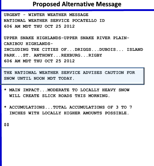
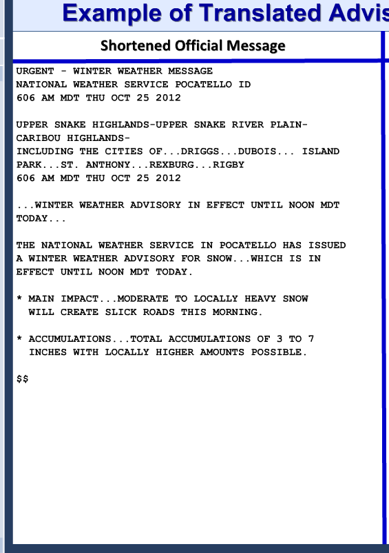
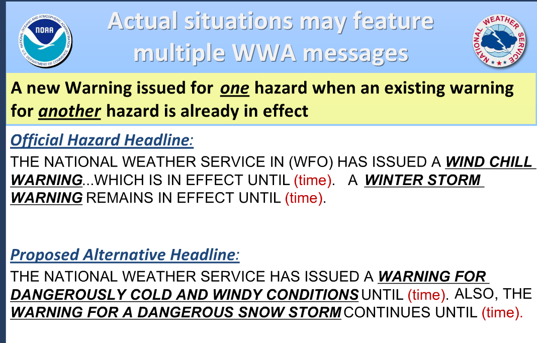
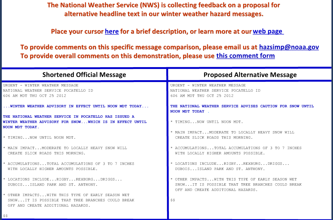
Better way to write watches and warnings
Better way to write
winter storm
watches
advisories
wording